Day 1
We arrived at the trailhead at 3:00pm
and started out on the Ruth Will Ski Trail following it for .5 miles where it intersected
the Black Forest Trail heading north. We followed the BFT for @ 8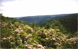 miles. The first day was
pretty uneventful. The trails were muddy and rocky. We had lots of downhills
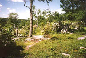
and very little elevation. The mountain laurel was in full bloom which made
for spectacular foliage. At one point as we were scampering around the ridge, the woods disappeared
momentarily and opened into a clearing.
miles. The first day was
pretty uneventful. The trails were muddy and rocky. We had lots of downhills
and very little elevation. The mountain laurel was in full bloom which made
for spectacular foliage. At one point as we were scampering around the ridge, the woods disappeared
momentarily and opened into a clearing.
What a magnificent vista! The clearing was so unusual...it looked like a picture right out
of the movie, "Heidi" with it's flowing hilly contours, steep sloped
trails, beautiful foliage, and plentiful mountain laurel.
I started calling out, Grandfather... Grandfather...where are
 you?" And I expected
Goat Peter to come charging down the hill any minute blowing his horn! Dave thought
perhaps I was in the sun too long :^)
you?" And I expected
Goat Peter to come charging down the hill any minute blowing his horn! Dave thought
perhaps I was in the sun too long :^)
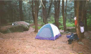
We wanted to travel as far as we could the first day following the stream and camping
right before the trail veered away from our water supply. We arrived at our campsite
around 7:30pm.
It was a beautiful pine grove with very large boulders which made it nice
to cook on. Due to the warm and humid day we opted to keep the fly off as we weren't
expecting any rain and we hoped to see the stars. Due to the heavy pines it was difficult
to see any sky but I knew it was up there :^)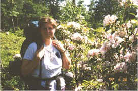
Day 2
After a light breakfast and filling
water bottles, we broke camp and headed out about 10:00am. We stayed on the BFT for @ 1
mile and then crossed Rt. 44 where the BFT intersected the Sentiero Di Shay Trail. Both
trails continued together for @ 2 miles. We left the BFT right before it descended into
the Pine Creek Valley and we continued on the Sentiero for @ 5 miles.
Along
this stretch I decided we needed some excitement so I took a nose dive into
the dirt. What a funny feeling to have your house fall on you :^)
Anyway, a little further down the trail we came upon a 4' black rattlesnake!
Dave yelled to get back and as soon as I saw it, it started coming my way so
I ran screaming back down the trail =8^O It was only
trying to get off the
 trail
and up the bank. I could've sworn it was after ME :^)
trail
and up the bank. I could've sworn it was after ME :^)
A few yards down the trail a white-tailed deer crossed our path...what a
beautiful site! She was too quick for a photo op.
We then followed the George Will Ski Trail for about 2 miles back to our vehicle around
2:00pm. We noticed quite a few cars at each trailhead, however, we only came
across 2 hikers in all on the trails we were on.
We did
follow a group of horse riders the first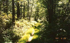 day and figured we were just minutes behind
them. The second day my pack aggravated an old back injury to the point we had
to stop every 1.5 to 2 miles. I'm blaming it on the fall I took earlier in the day.
Otherwise, this was a great combination of trails with very little elevation. I wouldn't
mind doing it again some day.
day and figured we were just minutes behind
them. The second day my pack aggravated an old back injury to the point we had
to stop every 1.5 to 2 miles. I'm blaming it on the fall I took earlier in the day.
Otherwise, this was a great combination of trails with very little elevation. I wouldn't
mind doing it again some day.
My 2nd backpacking trip :^)
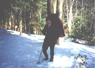 50's and the nighttime
lows were around 20 so I thought this would be a good time to go for it! I
didn't want to do a long trip not knowing how I would handle the conditions
so we opted to do a short trail. There was about 8-10 inches of snow on the
trail so we took the snowshoes just in case.
50's and the nighttime
lows were around 20 so I thought this would be a good time to go for it! I
didn't want to do a long trip not knowing how I would handle the conditions
so we opted to do a short trail. There was about 8-10 inches of snow on the
trail so we took the snowshoes just in case.