|
This trail
combines the Seneca Trail, the Moss Hanne Trail and the Star Mill Trail. With very little
elevation this trail is a very doable day hike. We've hiked it several times now and
always find something new to enjoy about it each time.
The park is located in Moshannon State Forest at the junction of PA 504 and the Julian
Pike. The hike starts at this point...begin by crossing the bridge, keep left along the
roadside past the boat-rental area; at the Westside Road/PA 504 junction, bear left up the
bank of an unmarked trail. Go passed Cabin P6 and turn left. After 100 meters turn left
again, soon reaching a junction with the white-blazed Seneca Trail.
Turn right on the Seneca Trail and follow it to where it joins the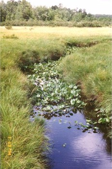 Hayroad Trail. Continue
on to the junction with Indian Trail, turn left and follow Indian Trail through a pine and
spruce growth as far as the Moss Hanne Trail. Along the first stretch, the Moss Hanne Trail crosses the head of a long,
swampy lake, then on higher ground passes several old beaver dams. Hayroad Trail. Continue
on to the junction with Indian Trail, turn left and follow Indian Trail through a pine and
spruce growth as far as the Moss Hanne Trail. Along the first stretch, the Moss Hanne Trail crosses the head of a long,
swampy lake, then on higher ground passes several old beaver dams.
Although the trail in this part is just a short distance from an access road
to the local airport, it feels remote as it winds through open woods and
dense stands of pine and spruce, traversing both high ground and the marshy
areas.
At 6.0 km the trail follows a relocation through the woods to avoid some
wet spots. Before reaching the airport fence, the trail turns left on a boardwalk through
an alder swamp. At the far end the Moss Hanne Trail turns left again
in sight of the fence enclosing Mid-State Airport. (The fence and cattle
gate on the access road are supposed to keep deer off the runways).
The trail veers from the fence, circles the end of a runway, and passes
between the approach lights. You can see Rattlesnake Mountain down the approach light
path.
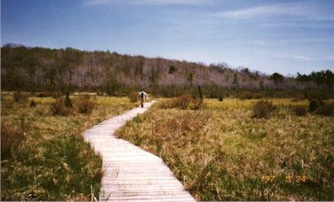
You now leave the woods and take another boardwalk across a broad, marshy area, where you
cross Black Moshannon Creek on a new bridge. Once across the bridge you climb
into the woods, passing the blue-blazed Aspen Trial on your right.
 Bear left, then right, and
follow a faint woods road across higher ground to another marshy area of the
lake. You cross what seems to be a small strip mine and can see
pieces of coal on the path and small piles of coal in
the brush. Bear left, then right, and
follow a faint woods road across higher ground to another marshy area of the
lake. You cross what seems to be a small strip mine and can see
pieces of coal on the path and small piles of coal in
the brush.
You then pass the other end of the Aspen Trail and turn left off the woods
road. Cross a small stream and bear left and pass a large spring. Here you see
old beaver dams on your left, an active dam farther ahead, and a beaver lodge in the pond.
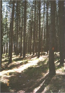
The trail then bears east, gradually veering away from the lake, passes through a dense
stand of hemlocks, and crosses high ground before entering another pine plantation.
Take a cordovan trail through the marsh along Shirks Run, and cross the run on a bridge to
reach Julian Pike. Turn left and walk along the road. After crossing Smays Run, take
a sharp left onto the unblazed Star Mill Trail and follow it along the lake's edge.
After 1 km bear left on the road at the cottage and return to Julian Pike.
Continue walking down the road until you reach the boat launching area and your car.
|