Day 1 - 7.8
miles
Left home at 1:30pm and arrived at the
trailhead @ 3:00pm which is located at World's End State Park in the Loyalsock Canyon of
Sullivan County. They like you to park at the park office which is nice knowing that the
park security force is close enough to hopefully keep a watchful eye on your vehicle while
you're on the trail.
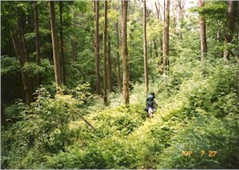
We headed out past the park office and the concession stand, passing through the picnic
area on the Loyalsock Trail. About 1/4 mile in we passed a sign identifying the
lowest point in Sullivan County where you begin the hellish climb straight up on the High
Rock Run Trail. A part of the steep hill climb has been rerouted - the trail passed
dangerously close to the brink of the cliff and at least 2 hikers have fallen to their
deaths there. The trail gets steeper yet from this point reaching High Rock Vista. 2
hikers headed out before us from the parking area and we passed them on this steep uphill.
We didn't see them at the campsite that evening and figured they must have given up?
At the vista we left the High Rock Run Trail and continued on the
Loyalsock Trail. Here we climbed an old road grade and past a spring that emerges under a
tree. Unfortunately the streams and springs had all but dried up??
We were a little concerned at this point for further water supplies. A group of 7
"kids", probably college age, passed us coming the opposite direction...they
hiked the trail in reverse and were on their last section of the trail.
After the spring we crossed High Rock Run and turned onto High Rock Spur
which is an old logging railroad grade. Hemlock, beech, chestnut oak, and white pine line
the path. Down the path we passed the remains of a beaver pond and followed an old
railroad grade. Climbing up a sloped grade we rested at Ken's Window. Then we made our way
above Tom's Run and followed it upstream past Alpine Falls. We continued climbing and
crossed Tamarack Run and climbed up and over some large rocks known as Porky Den (which is
home to an old porcupine). The trail continues on a series of old wood roads to Sones Pond
- our campsite.
Coming upon the campsite area was so bizarre. The pond was huge so we thought there would
be no problem finding a campsite way out in the wilderness. The closer we got to the pond
I noticed a bed blanket spread under some pines with a cooler. The next campsite down had
a large dome tent, a canopy and the people there were not dressed for hiking. I couldn't
figure out how in the world this could be. We kept walking and got closer to the edge of
the pond and looked out and saw canoes and boats and people across the pond. There was a
road access to this spot somewhere and it appeared to be a very popular camping area. We
chose a spot away from the action in case this was a party area. It turned out to be a
very quiet group of people.
We got to our campsite at 7pm and set
up camp. Dave ventured to the pond's edge to fill up the water bottles in preparation for
dinner. There was plenty of water there but access to it wasn't easy and the water that
could be accessed was very green with algae and questionable. We had a quart of water
leftover that we brought with us and decided to keep that as drinking water for the
evening and boiled the water we got from the pond. It wasn't easy getting the water, the
algae kept clogging the filter. Dave put potable aqua tablets into the water so it would
be okay for the next day's hike.
Day 2 - 9.6 miles
Broke camp @ 9:50am and headed along the shore of Sones Pond through a
spruce plantation along Rock Run. We continued to the edge of the Loyalsock
Canyon and descended along rock ledges.
We picked up a woods road which is on a level bench. We then descended very
steeply along an old log skid. The hike down was reminiscent of a jungle
with lots of overgrown vegetation.
 Along this stretch we stopped to enjoy the yummy black raspberries that
were abundant all along the trail :^) Along this stretch we stopped to enjoy the yummy black raspberries that
were abundant all along the trail :^)
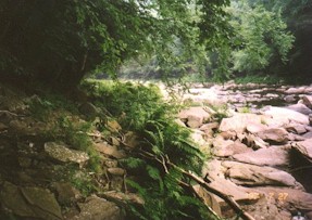
We then traveled on Haystacks Road and crossed a bridge over Mill Creek and began to look
for a different trail marker, this being for the Link Trail.
At the bridge we saw a healthy stream so we took a break on some large rocks in the stream
and dumped our water from the night before and opted to pump some filtered stream water
into our bottles. We felt much better doing this.
We
traversed wet and slippery rocks at the base of a cliff downstream for a ways (I don't
like wet rocks!). Crossed Shanerburg Run on the highway bridge and then we turned onto an
old grade.
We were in store for some more serious climbing. The trail continued on a number of old
grades onto an old logging road past several springs. The trail then crossed Cold Run and
we reached the top of the hill and continued through the woods crossing more dried up
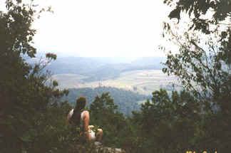
streams. We picked up the Loyalsock Trail and carefully worked our way around some large
rocks at the cliff's edge to Canyon Vista. Beyond the vista, the Link Trail diverges from
the Loyalsock Trail and descends into the valley of Double Run. The trail winds over and
around boulders along waterfalls.
We then picked up an old logging railroad grade and turned onto the Loyalsock Trail again.
We crossed both branches of Double Run and made our way along the edge of the bouldery
Loyalsock Creek to the bridge. At this point we retraced our steps back to the picnic area
and the park office to our vehicle at 3:30pm
Very challenging hike...not one that I want to do again any time soon but some day I'm
sure. The very high humidity made it rough on us throughout the trip. Only wildlife we saw
was 3 snakes and heard a 4th. Also saw 2 grouse, some squirrels, and lots of toads.
We completed the trail in less time than we expected and still enjoyed the great vistas
and backcountry...after all, that's the reason for being
there...to enjoy!
My 4th trip :^)
9/13/98
First section of the Loyalsock Trail as described in
Tom Thwaites book, 50 Hikes in Central Pennsylvania
Location: 8.8 miles north on PA 87 from the junction with I-180
(US 220) near Montoursville, PA
Length: 6.3 miles
Total trip elevation gain: 1,165 ft.)
According to the article in Tom Thwaites' book, 50 Hikes in
Central Pennsylvania, this rugged hike is on one of the oldest maintained
trails in Central Pennsylvania. The LT was first marked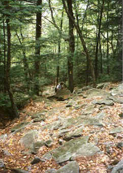 in 1953 and 10 years later was
extended and extensively relocated. in 1953 and 10 years later was
extended and extensively relocated.
At the trailhead we immediately began climbing steeply through breaks in the cliffs. Above
the cliffs the climb eases off. Higher up the rocks you have to pay close attention to the
markers (trust me - I took the wrong path - not a good thing to do on a steep climb!).
At 1km we passed a large sandstone boulder named Sock Rock, in another 200 meters we
FINALLY reached the top of the mountain. Laurel Flat, the plateau, is covered with
mountain laurel - not in bloom however at this time of year.
At 2.5km we reached a junction of woods roads. Here the road to the left
is marked with a Red X and rejoins the LT near the head of Pete's Hollow. We continued on
the other road across two small streams. We followed the trail left at a fork and left
again when it leaves the road.
We climbed over more rocks and arrived on the Allegheny Front at 3.6km. Along this section
Dave held out his arm to stop me. It took me a few seconds to see IT!!!! There was a 4
foot
 black rattlesnake sunning himself on the trail! He was very displeased with our
presence. He quickly coiled up and rattled his heart out!! We took some great shots of the
LITTLE fella. He appeared to be about 3.5 inches round and had about a 2.5 inch rattle! We
were hoping he'd move nicely off the trail so we could conveniently walk on by but
nooooooooooo...he decided to stand his ground (how rude!! *lol*) so we skirted out around
him. We could hear him for quite a distance! black rattlesnake sunning himself on the trail! He was very displeased with our
presence. He quickly coiled up and rattled his heart out!! We took some great shots of the
LITTLE fella. He appeared to be about 3.5 inches round and had about a 2.5 inch rattle! We
were hoping he'd move nicely off the trail so we could conveniently walk on by but
nooooooooooo...he decided to stand his ground (how rude!! *lol*) so we skirted out around
him. We could hear him for quite a distance!
One of the few places along the Allegheny Front in PA that offers a walk
along this dividing line with many overlooks of North White Deer Ridge.
According to the guide book, if you hike in June, you may witness the antics
of a hen grouse. While her chicks scurry in one direction, she displays her
tail feathers and runs across the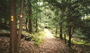 trail, cheeping piteously, with one wing dragging as if broken.
You are expected to fall for this age-old ruse and follow her into the
woods. The "broken wing" mends miraculously, and the hen takes flight to circle
around and gather her brood. On this trip I think we saw at least a dozen or so grouse.
At 5.6km we turned right on a woods road and passed the Red X trail on our left. We turned
left at the next junction and at 6km we turned left again to head down Pete's Hollow. A
short way along a clear-cut on our right offered a view of Smith's Knob across Little Bear
Creek Valley.
The trail down Pete's Hollow
was very rough and rocky, so we had to move carefully on the wet boulders.
Toward the bottom we picked up an old road grade called Peter's Path - we
crossed Little Bear Creek then turned left on a forest road. In 100 meters
the LT turns right and climbs over Smiths Knob but our trail continued
ahead and at 9.3km we turned left on PA 87 for the short walk back to our
car. |