|

Ohiopyle State
Park
Meadow Run Trail
7/16/00
Location: Ohiopyle State Park in southwestern PA
Length: 3.2 miles
Total trip elevation gain: 445 ft.
|
|
The trailhead is located at a parking area on SR 2011. There are
three trails close to the parking area, take the one farthest to your right.
You'll see a post with a missing trail sign. This trail is marked with yellow
blazes.
You start out by climbing up a hill. Around a half mile in, be alert
for a critical turn in the trail.
You want to bear left and eventually you'll be descending stone steps
along some cliffs. The trail follows around the base of these cliffs. You'll
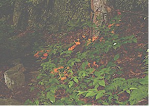
come across a side trail to view a small cascading waterfall. You won't want to miss
this beautiful side trail.
The trail continues downstream and then you begin a climb
back up the hill through some beautiful rhododenrons and hemlocks.
There are several side trails that take you back to the streams' edge for a closer vantage
point. You can continue on the trail to reach "the slides".
The slides are slippery rocks that you can use as a sliding board into the water...they
are extremely slippery. It's a favorite swimming area in the summer.
When you're done checking out the slides, retrace your steps to the yellow-blazed trail and
back to the parking area. |
|
|
Ferncliff Trail
7/16/00
Location: Ohiopyle State Park in southwestern PA
Length: 2.1 miles
Total trip elevation gain: 200 ft. |
|
 The trailhead can be reached from PA 381. Turn into the parking lot
before you reach the two tracks of the Baltimore & Ohio Railroad. In the parking
area, you'll see a sign for the trail. The trailhead can be reached from PA 381. Turn into the parking lot
before you reach the two tracks of the Baltimore & Ohio Railroad. In the parking
area, you'll see a sign for the trail.
The Ferncliff Trail is a self-guided nature trail marked by black blazes. You'll go
under the old Western Maryland Railroad bridge to a trail junction and marker noting that
this trail was declared a national natural landmark in '73. Follow the trail as it
bears to leads to the water's edge.
You'll then turn back into a tunnel. Around .5 miles in you turn left for a vantage
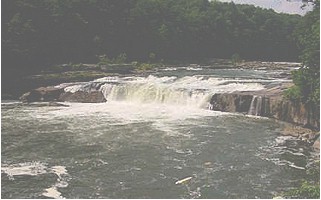
point view of Ohiopyle Falls.
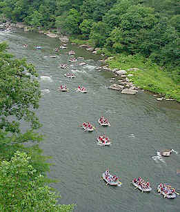
From this view you can
see the put-in area for the lower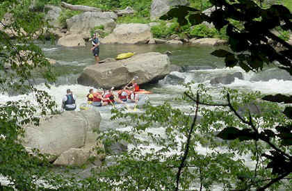 Yough and rafters and kayakers getting ready to conquer
Class III and IV rapids. Back on the trail you climb up to a cliff where you reach
another overlook. Yough and rafters and kayakers getting ready to conquer
Class III and IV rapids. Back on the trail you climb up to a cliff where you reach
another overlook.
Continue on the trail where you can hear the rapids but there is no vantage
point. You can follow the Take-out Trail loop to the foot of
Railroad Rapids for a vantage point of the rafters below. Then
proceed back to the parking area. |
|
|
Ohiopyle State Park
7/14 - 7/16/00
Location: Ohiopyle State Park in southwestern PA |
|
|
 |
 |
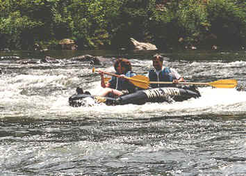
Going down the Middle Yough on
Class I & II rapids. I loved it!!! |
Ohiopyle waterfalls. |
|
|
Twenty-eight
miles of an abandoned railroad right-of-way have been converted to a smooth, hard surface
trail for bicycling and hiking. This trails is called the Youghiogheny River
Bike/Hike Trail. It parallels the Youghiogheny River between the Ramcat parking area
near Confluence to
the towns of Connellsville/ Dunbar.
The trail
features scenic views of the river and cascading feeder streams. It is also an excellent
area to see many species of wildlife that frequent the park. The bike trail is
suitable for all ages. Rental bikes are available from several outfitters in town.
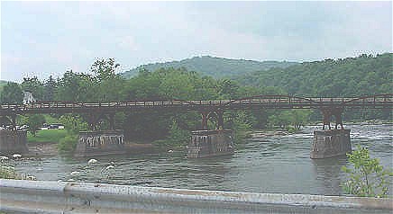
A section of the bike trail (a converted
train bridge). |