|
The trailhead is at the district office for the Susquehannock State
Forest, located on the south side of US 6 at the top of the hill between Denton Hill State
Park and Sweden Valley. We parked along the road between the office building and the
equipment garage. The hike began at the gate on the road just beyond the garage. The road
is blue-blazed as a xc ski trail. It bends first right, then left, where we turned right
onto a blue-blazed trail that is part of the Ridge Trail.
At 670 meters we reached the Susquehannock Trail. The trail register is on the left but
turn right onto the orange-blazed White Line Trail. The route of the STS is protected by a
no-cut buffer. The cloverlike plant on the ground is oxalis or wood sorrel, and the
toxic oxalic acid in its juice accounts for its sharp taste. At 2.0 km we crossed Lyman
Run Road and then began the long descent into Splash Dam Hollow.
At the junction with SDH, the STS turns right but we turned left onto an unmarked trail.
It became more distinct as we moved downstream. Several beaver dams were visible along the
stream. Slash dams were built on small streams to help float logs to sawmills.
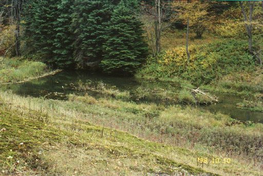
Beaver dam at Lyman Run.
At 6.2km another old
grade comes in from the left where we continued ahead on the trail (do not
cross stream). A beaver dam has deepened the ford of Lyman Run so we took
the detour upstream on a fisherman's path and crossed above the pond. At
7.1km we turned left on Lyman Road. At 8.9km we turned right on the unmarked
and little-used Township Trail. We had a little trouble trying to figure out
where the Township Trail was but our guess was correct.
This took us up a hollow. Too many rocks made it difficult to find a path so
we used the compass to guide us north to the top where we were to cross a
logging road at 10.1km. Here we continued north. We used the compass to
guide us to meet up with the STS at 10.4km coming in from the west. We
proceeded along the Ridge Trail to the junction with the blue-blazed trail
at the trail register. We retraced our steps to the forestry office and back
to the car at the Northern Gateway. |